How Many Trees Are in New York City?
It’s easy to lose track of things like fresh air, wide open spaces and nature while traipsing around congested city streets, but New York actually has an abundance of trees and greenery that you’d notice if you ever slowed down and observed your surroundings once in awhile.
But to get a better picture of exactly how many trees line the city’s streets, the Parks Department is crowdsourcing data for its Trees Count! 2015 project, a tech-savvy yet still totally old school affair that will see volunteers record data using equipment like measuring wheels and mobile-friendly apps.
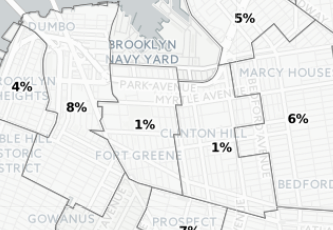
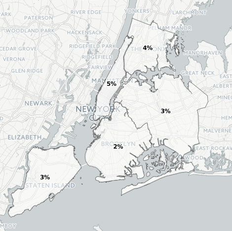
Participants will be armed like park rangers, walking around different neighborhoods with tree identification guides and tape measures, recording data that will eventually trickle into an interactive map that encompasses all five boroughs. The map, which is currently only sparsely filled-out, indicates that the volunteers willing to shuffle around different neighborhoods this summer have their work cut out for them. Currently, no borough has over five percent of its trees mapped: Manhattan leads the pack (5%) and the Bronx trails closely behind (4%), while Staten Island and Queens (3%) just edge out Brooklyn (2%).
The map lets you examine the data on a really granular level, as you can zoom in to see exactly what city streets have been tracked. The interactive even lets you plug in a specific address to see if your street is overrun with data-crunching tree-lovers.
The reason for the program’s meager beginnings might be the rather involved nature of tree mapping in general, but the endeavor should make for a pretty cool summer excursion, as well as something educational for kids across the city to enjoy.
So far, only 21,849 New York City trees have been recorded across a span of 4018 city blocks. If you’re interested in taking a look a the map in interactive form, you can do so here. You can also sign up to be one of the city’s “voluntreers” by following the same link.
You might also like 


